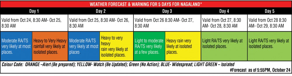
Source: Table based on ‘Weather Forecast & Met. Warning For 5 Days’ issued by IMD’s Regional Met Centre (RMC) Guwahati on October 24.
Morung Express News
Dimapur | October 24
The Cyclonic Storm “Sitrang” (pronounced as ‘Si-Trang’) moved north-northeastwards and lay centered over North Bay of Bengal on October 24 evening, bringing widespread rainfall across Nagaland during the day.
Updates by the India Meteorological Department (IMD) on Monday evening at 8:15 PM informed that the cyclonic storm “very likely to continue to move north-northeastwards” and cross Bangladesh coast between Tinkona Island and Sandwip close to Barisal during midnight October 24 or in the early hours October 25.
Accordingly, it forecasted the continuation of ‘light to moderate rainfall at most places with heavy to very heavy rainfall at isolated places is likely over the North East States in the next 2-3 days.
The IMD’s rainfall data for October 25 from 8:30AM-5:30PM informed that rainfall or thundershower were observed at most places over Arunachal Pradesh, Assam & Meghalaya and Nagaland, Manipur, Mizoram and Tripura affecting the normal life and dampening the Diwali celebration in the region.
Rainfall as also observed few places over Gangetic West Bengal and Kerala and Mahe; and at isolated places over Sub-Himalayan West Bengal & Sikkim, Andaman & Nicobar Islands, Odisha, Lakshadweep and Tamil Nadu, Puducherry & Karaikal.
Among the chief amount of rainfall (1cm, or more) observed, Agartala and Shillong led with 4 centimetre each, while Cherrapunji and Kohima received 3 cm each. Canning, Kailashahar and Lumding had 2 each while Imphal, Guwahati, Golaghat, Jorhat, Aminidivi, Tondi and Long Island received 1 each.
In Nagaland commercial capital Dimapur, it rained through the day on October 24, with some unofficial account putting the amount of rainfall at 2 CM.
However, no untoward incidents were received here till the filing of this report, though there were erratic power supply throughout the day.
More rainfall in offing
Meanwhile, the IMD’s Monday evening update informed that “heavy to very heavy rainfall at isolated places very likely over Arunachal Pradesh, Assam, Meghalaya and Nagaland, Mizoram, Manipur, Tripura and heavy rainfall at isolated places over coastal districts of West Bengal on October 25.
On October 26, the national weather forecaster also predicted that heavy rainfall is “very likely” over Arunachal Pradesh, Northeast Assam and Nagaland.
Likewise, state-wise updates for NE States by the IMD’s Regional Met Centre (RMC) Guwahati on October 24 informed that ‘heavy to very heavy rainfall at isolated places’ as well as ‘moderate rainfall or thundershower’ at most places are “very likely” on October 25.
There is ‘very’ likelihood of heavy rain very at isolated places as well as ‘Light to moderate rain or thundershower’ a few places on October 26 and 27, it added.
The Centre issued “Orange’ alert till the morning of October 25 in some locations and Yellow on October 26 and 27.
There is possibility of light rain at isolated places thereafter but rainfall activity will decrease from October 29, the RMC update informed.
Meanwhile, the Nagaland State Disaster Management Authority (NSDMA), Home Department issued another advisory that on October 24, which among others, directed all District Disaster Management Authorities (DDMAs) and concerned department are to be prepared and vigilant for any eventualities including disruption to normal services and activities in their respective districts.