Source: India Meteorological Department, Regional Meteorological Centre
Morung Express News
Dimapur | April 20
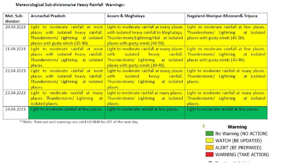
Fairly widespread to widespread rainfall activity “with heavy rainfall/hail/thunderstorm lightning with gusty winds” is likely to continue over the North-East including Nagaland for the next three days till March 23, informed the IMD’s Regional Meteorological Centre, Guwahati on April 20.
Accordingly, for Nagaland, it forecasted ‘light to moderate rainfall at few places’ and ‘thunderstorm/ lightning at isolated places with gusty winds (40-50km)’ on April 21.
While ‘light to moderate rainfall at many places’ was predicted for April 22, the intensity of gusty winds is expected to decline to 30-40km on April 22. On April 23, the regional met office informed that there is likelihood of ‘light to moderate rainfall at many places’ and thunderstorm/ lightning at isolated places in Nagaland and the other NE States.
The rainfall activity as per the five-day bulletin is expected to decline considerably by April 24 with light to moderate rainfall at few places’ all over the region. (See table).
The MET office attributed the present weather pattern to cyclonic circulation lies over north Bangladesh & neighbourhood at 0.9 km above mean sea level and trough running from east Bangladesh to Northwest Bay of Bengal at 1.5 km above mean sea level.
“Moisture incursion due to strong low-level Southerly/Southwesterly winds from the Bay of Bengal to Northeast India is very likely during April 20-23, it added.


.jpg)