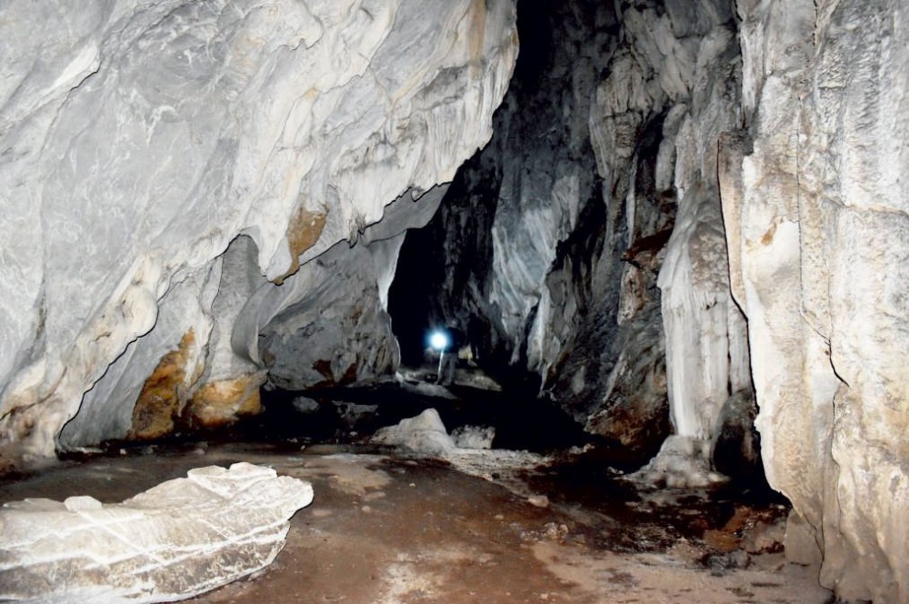
A limestone cave in the Chipur area of Noklak district photographed during a geo-tourism potential assessment by the Department of Geology and Mining in 2025. (Photo Courtesy: DGM AAR 2025–26)
Department reports progress in coal exploration, hydel assessment and landslide studies
Morung Express News
Kohima | March 19
Limestone cave formations in Noklak district have been identified as having strong potential for geo-tourism development, even as the Department of Geology and Mining (DGM), Nagaland continues wider geological surveys across the State covering mineral exploration, hydropower potential and landslide assessments.
According to the department’s Annual Administrative Report 2025–26, several geological investigations were carried out during the year including studies on limestone deposits, coal exploration, and geotechnical assessments.
Among the studies undertaken, the department assessed the geo-tourism potential of limestone caves in Chipur village, Noklak district in April 2025.
The survey examined four limestone caves exhibiting notable karst features and speleothem formations, which are considered important indicators of geo-heritage value, it said.
It indicated strong potential for adventure and nature-based tourism with appropriate conservation and infrastructure support, it added.
As per the department, among the surveyed sites, Piolingka Cave, estimated to be about 300 feet deep, is the most suitable location for geo-tourism development due to its accessibility and notable geological formations, it added.
Meanwhile, exploration in the Pang–Chipur area, covering about 7.6 km, included geological mapping as well as chemical and physical laboratory analyses to assess the occurrence and quality of limestone associated with the Naga Hills Ophiolites.
In Kiphire, the department carried out boundary mapping and DGPS-based pillaring were undertaken for the Mimi-Pyakatsu and Mimi-Kheti limestone blocks, covering a combined area of 8.33 km.
Preliminary exploration was also conducted in the Khongkha limestone block, covering 2.34 km while in Mimi-Kheti block, geological mapping covered 2.2 km², while DGPS-based topographical surveys covered 2.6 km² since April 2025, against a total target area of 3.54 km².
Coal exploration
Regional coal exploration also continued in three blocks of the Melak–Tzurang Valley coalfield in Mokokchung district between August 2024 and July 2025.
In the Tuli–Yimchenkimong block, a total of 1,067.60 metres of drilling across four boreholes was completed.
In the Waromung block, 1,270 metres of drilling across seven boreholes were carried out, while 3,991.90 metres of additional drilling is planned to reach the target depth.
Geological mapping at 1:10,000 scale over an area of about 13 km² was undertaken to demarcate coal seams within the Mekokla–Changki block, the report said.
Two workable coal seam zones, each with thickness of approximately 1.0–1.5 m, were identified and further regional exploration is recommended for refined assessment, it added.
Landslide and other investigations
The report further noted that geotechnical studies also examined landslide-prone areas and road stability issues in parts of the State.
A geological investigation near Viswema village along National Highway -2 identified three landslide zones and recommended mitigation measures including sub-surface drainage, slope reinforcement, terracing and plantation.
A GIS-based landslide susceptibility study of Kiphire town also documented 21 landslide locations, most of them concentrated in the Medical Colony area, the report stated.
Meanwhile, mitigation work was carried out along NH-2 near Chiechama village, where a sub-surface drainage system was installed after preliminary investigations identified pore-water pressure build-up as the primary cause of gradual road subsidence. It is expected to improve stability by lowering pore-water pressure and prevent further subsidence, it added.
The department also investigated the extraction of sand, gravel and boulders from the Chathe and Dhansiri riverbeds in Dimapur and Chümoukedima districts.
A feasibility study based on satellite imagery, geological mapping and hydrological assessment also identified five potential mini-hydel sites—three in Kohima district and two in Chümoukedima district, the report informed.
Preliminary analysis indicated medium to large hydel potential with favourable conditions for earth dams in Chümoukedima and concrete dams in Kohima, depending on watershed size, discharge and valley geometry, it added.