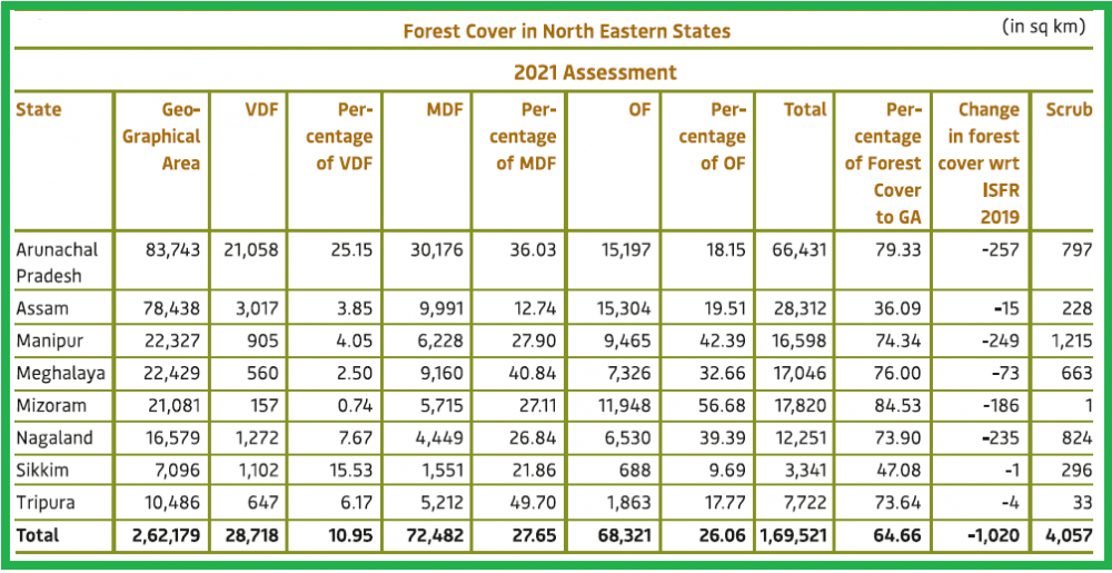
Status of forest cover in North-East India in 2021. Source ISFR 2021.
While national forest cover increased, NE States lost 1,020 sq km of forests
Morung Express News
Dimapur | January 13
Nagaland recorded a 235 square kilometre decline in forest cover during the 2019-21 period, informed the ‘India State of Forest Report 2021’ (ISFR) prepared by the Forest Survey of India (FSI) and released on January 13. Headquartered at Dehradun, the FSI is mandated to assess the forest and tree resources of the country.
As per the report, Nagaland had a total area 12,251 sq km designated as ‘forest’ denoting 73.90% of its total geographical area of 16,579 sq km.
The decline in forest cover in Nagaland is among the highest in India.
However, all the North-East States—Arunachal Pradesh, Assam, Manipur, Nagaland, Tripura, Mizoram, Meghalaya and Sikkim reported loss in forest cover, ranging from -257 sq km in Arunachal Pradesh to -1 sq km in Sikkim.
The loss in forest cover in Arunachal Pradesh was highest in India, followed by -249 sq km in Manipur and -235 sq km in Nagaland.
The decline in forest cover in other NE states were: Mizoram (-186 sq km), Meghalaya (-73 sq km), Assam (-15 sq km), Tripura (-4 sq km)
Overall, the 8 NE states lost 1,020 sq km in forest cover during 2019-2021, highlighted the ISFR 2021 released by the Union Minister for Environment, Forest and Climate Change, Bhupender Yadav on January 13.
As per an official statement, the total forest and tree cover in India in 2021 was 80.9 million hectares, denoting 24.62% of the geographical area of the country.
Sharing the findings, Yadav informed that as compared to the assessment of 2019, there is an increase of 2,261 sq km in the total forest and tree cover of the country, the statement said.
The Minister expressed happiness over the fact that the present assessment revealed that 17 states/UT’s have above 33 percent of the geographical area under forest cover, it added.
Major Findings
As compared to the assessment of 2019, there is an increase of 2,261 sq km in the total forest and tree cover of the country.
Increase in forest cover has been observed in open forest followed by very dense forest (VDF) and the top three states showing increase in forest cover were Andhra Pradesh (647 sq km) followed by Telangana (632 sq km) and Odisha (537 sq km).
Area-wise Madhya Pradesh has the largest forest cover in the country followed by Arunachal Pradesh, Chhattisgarh, Odisha and Maharashtra.
In terms of forest cover as percentage of total geographical area, the top five States are Mizoram (84.53%), Arunachal Pradesh (79.33%), Meghalaya (76.00%), Manipur (74.34%) and Nagaland (73.90%).
The total mangrove cover in the country was 4,992 sq km denoting an increase of 17 sq Km as compared to the previous assessment of 2019.
Top three states showing mangrove cover increase are Odisha (8 sq km) followed by Maharashtra (4 sq km) and Karnataka (3 sq km).
Meanwhile, the total carbon stock in country’s forest is estimated to be 7,204 million tonnes and there an increase of 79.4 million tonnes in the carbon stock of country as compared to the last assessment of 2019.
The annual increase in the carbon stock is 39.7 million tonnes, added the statement from the Ministry of Environment, Forest and Climate Change, Government of India.
Forests in India are broadly classified as very dense forest (VDF), moderately dense forest (MDF), open forest (OF) and mangrove.
.JPG)