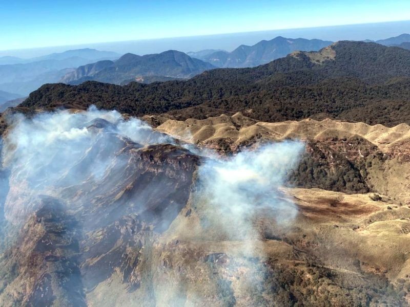
Arial view of a fire incident at Dzükou Valley, first reported on December 29, 2020 and lasted for nearly two-weeks. (Photo Courtesy: CMO Nagaland/Morung File)
Morung Express News
Dimapur | January 17
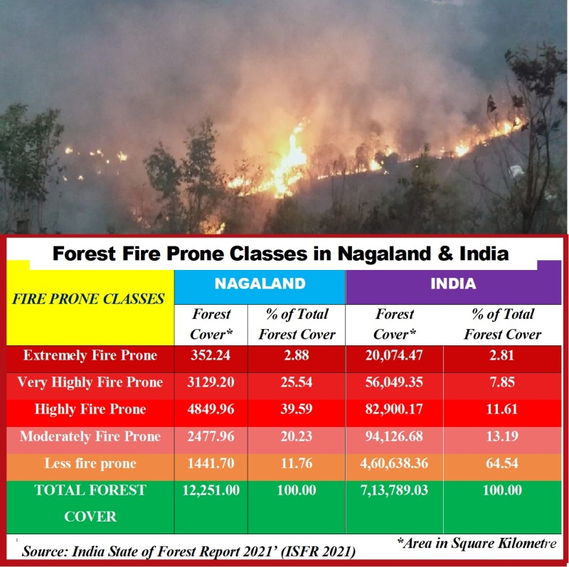
Affirming what has become an annual feature in Nagaland during the dry season, a biannual assessment of India’s forest status by the Forest Survey of India (FSI) has highlighted that nearly two-third of the State’s forest areas are either extremely, very highly or highly fire prone.
Out of total forest cover of 12,251 square kilometre in Nagaland, an area of 8,311.34 sq km or 68.1% were under the aforementioned three classes of forest fire proneness, informed the ‘India State of Forest Report 2021’ (ISFR 2021) prepared by the FSI, under the Union Ministry of Environment, Forests and Climate Change.
The FSI, mandated to assess the forest and tree resources of the country, released its 17th assessment on January 13.
As per the report, forest fire proneness are divided into five classes - extremely fire prone, very highly fire prone, highly fire prone, moderately fire prone, and less fire prone.
Class-wise, while just 2.88% (352.24 sq km) of the total forest cover was under ‘extreme,’ an area of 3,129.20 sq km (or 25.54%) was under the ‘very highly fire prone’ classes.
The share of ‘highly fire prone’ area was highest at 4,849.90 sq km or 39.59% of the total forest cover area.
The three classes of ‘fire proneness’ covered an area of 8,311.34 sq km or 68.1% of total forest area in Nagaland, the report highlighted.
In addition, an area of 2,477.96 sq km of forest cover was slotted as ‘moderately fire prone,’ indicating that over 10,809 sq km (or 88.24%) of the total forest cover in Nagaland is prone to fire, ranging from moderate to extremely fire prone.
Only 1,441.70 (or 11.76%) of 12,252 sq km of forest cover was designated as ‘less fire prone.’
As per the report, States under the North-Eastern region showed ‘highest tendency of forest fire’ with states like Mizoram, Tripura, Meghalaya, Manipur, exhibiting ‘highest forest fire probability in terms of frequency of event occurrence.
Across India, however, 64.54% of the total forest cover of 7.13 lakh sq km was designated as ‘less fire prone.’
Meanwhile, FSI’s Moderate Resolution Imaging Spectro-radiometer (MODIS) detected 1,248 forest fires in Nagaland from November 2019 -June 2020. It increased to 1,726 from November 2020 to June 2021, the report said.
Another sensor SNPP-VIIRS (Suomi-National Polar-orbiting Partnership - Visible Infrared Imaging Radiometer Suite) also detected 2,905 fire incidents in Nagaland from November 2019 - June 2020 which later increased to 4,975 from November 2020 to June 2021.
During the assessed period, there was a major fire at Dzükou valley which lasted from last week of December 2020 to second week of January 2021. The valley is prone to annual forest fires. On January 7, 2021, another major forest fire occurred at a hillock near St Joseph College Jakhama.
Nagaland’s Fire & Emergency Services (F&ES) also informed that its personnel in Noklak, Dimapur and Kohima averted major jungle fires in three separate incidents on March 1, 2021.
Many fire incidents in interior areas, many a times, go unreported and are usually doused by villagers or locals.
Meanwhile as per the IFSR 2021, Nagaland recorded a 235 square kilometre decline in forest cover during 2019-2021, while a total area 12,251 sq km was designated as ‘forest’ denoting 73.90% of its total geographical area of 16,579 sq km.
Overall, the 8 North-East states lost 1,020 sq km in forest cover during 2019-2021 though the total forest and tree cover in India in 2021 increased by 2,261 sq km to 80.9 million hectares, denoting 24.62% of the geographical area of the country.

.JPG)